
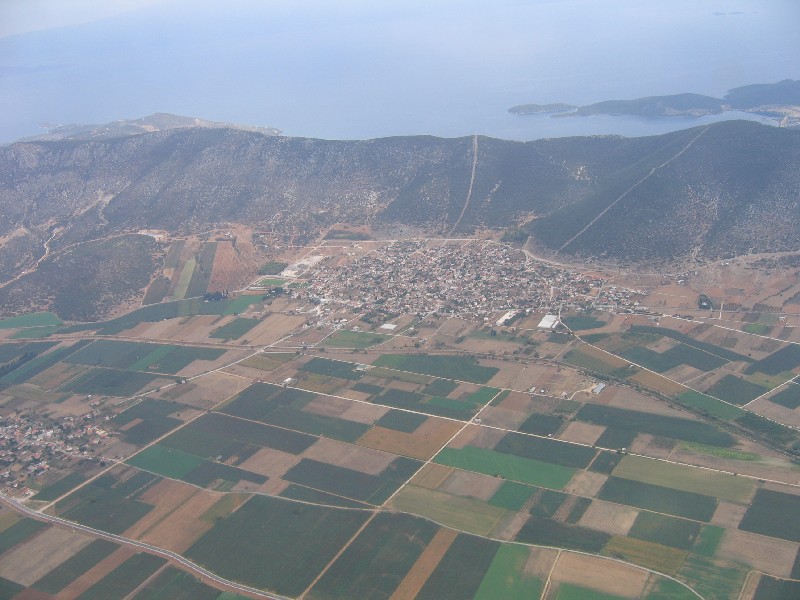
Sourpi is a Municipal Community of the Municipality of Almyros and has about 2,000 inhabitants. It is situated at an altitude of 30 m, built amphitheatrically at the foot of Kokkinovrachos (448 m) and Karagkini (300 m), which are extensions of Chlomos Mountain (893 m). Chlomos is a mountain range that starts from the Pteleos area and ends in the marine region of Amaliapoli. The entire village faces the sun, naturally protected from the northeast winds, and in front of it stretches the fertile plain, the ancient Athamantion Plain. It is located in the center of Greece, 275 km from Athens and 250 km from Thessaloniki. In relation to nearby cities, Almyros is 15 km away, while Volos is 50 km away. Very close to the village is the Athens-Thessaloniki National Road, and until 1963, the Old National Road passed through Sourpi, which today serves as the provincial road to Pteleos.
Sourpi has a long history, beginning approximately one thousand (1,000) years ago, during the Byzantine era. The present village can be referred to as modern Sourpi, which is why its historical development should be divided into two periods: the “old” village, from the Byzantine era up to the beginning of Ottoman rule, and the “new” village, from the 15th century to the present day.
The main occupations of Sourpi’s inhabitants are agriculture and livestock farming. In the wider area, olives, cereals, cotton, and other crops are cultivated. In the Sourpi plain, nearly 8 square kilometers are used for cereals, cotton, tomatoes, etc., while on the slopes and hills another 6 square kilometers are cultivated with olives, vineyards, almond trees, and similar crops.
In the livestock sector, many sheep and goats are raised in the wider area. In fact, Sourpi ranks as the second settlement in Magnesia, after Anavra, in the number of sheep and goats and in the tons of dairy products produced.